We in the article will explain all the locations and images from the Map that were in the news till now. Use the images of locations and explain through a Map that includes both Indian as well as global images
Indian Ocean
Agalega Island
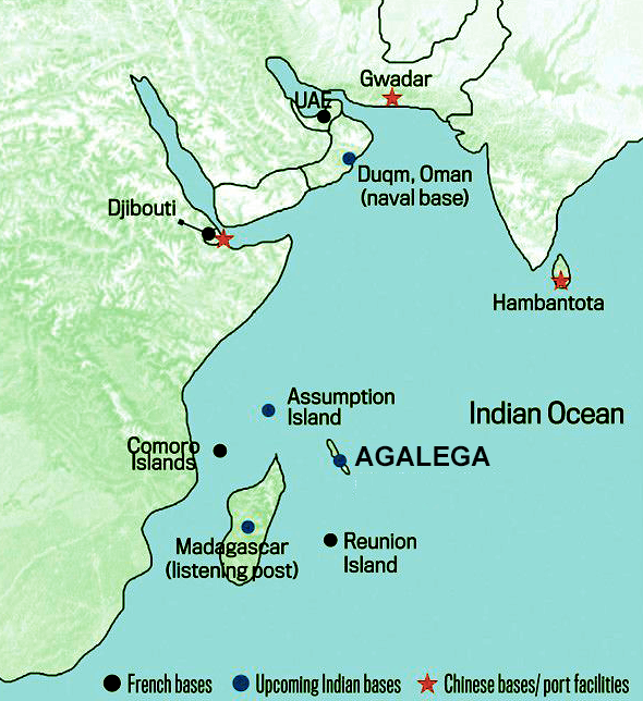
Agalega Island is present in the Indian Ocean it consists of two outer islands, which are made up of two islands. You should know where is located in the Indian Ocean. It can be asked in various government exams like UPSC, PSC, SSC, etc
Location through Map
It is located 1050 km north of Mauritius island. Agalega is a dependency of Mauritius. The two islands have a total area of 26 sq km and have a native population of about 300 people.
Government:
Agalega is run directly by the PM of Mauritius through the Prime Minister’s office to the Outer Island Development Corporation.
Now the big question is why you should remember it for the exam why was it news?
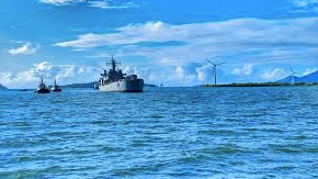
In February 2024, PM of India, Shri Narender Modi, and Mauritian PM Pravind Juganath jointly inaugurated an airstrip and the St. James jetty on North Agalega island in the Indian Ocean.
(you should know what An airstrip is it is like a long road where airplanes can take off and land and A jetty is a platform by the water where boats can dock and passengers or goods can be loaded or unloaded).
Benefits of this project for both countries:
1. The development of this project is significant for both Mauritian and Indian countries be it socially, economically and, you can say it is good for the national interest of Mauritius and also aligns with India’s vision for the Indian Ocean.
2. The new Jetty and the airstrip will enable a large and more credible government presence on the island. Do you know how let me explain to you The new jetty and airstrip on the island will allow the government to have a stronger and more visible presence there. With the jetty, ships can easily bring government officials, supplies, and equipment to the island, making reaching and supporting the local community easier. Meanwhile, the airstrip will enable regular flights to the island, facilitating quicker access for government personnel and resources. This enhanced accessibility will enable the government to better monitor, manage, and respond to the needs of the island’s residents, ultimately strengthening its presence and influence in the region.
3 . It will also help station or forward the deployment of the Mauritius Coast Guard ships.
Benefits for India:
- It will enhance the trust between the two countries. Help in building and maintaining the friendship.
- The joint development of the islands underscores India’s commitment to the vision of security and growth for all in the region (SAGAR), and its willingness to assist smaller maritime nations in building capacity and developing capabilities.
What is SAGAR?
Security and Growth for All in the Region is India’s strategic vision for the Indian Ocean, unveiled in 2015. Its goal is to strengthen economic and security ties with its maritime neighbours while also assisting them in developing maritime security capabilities.
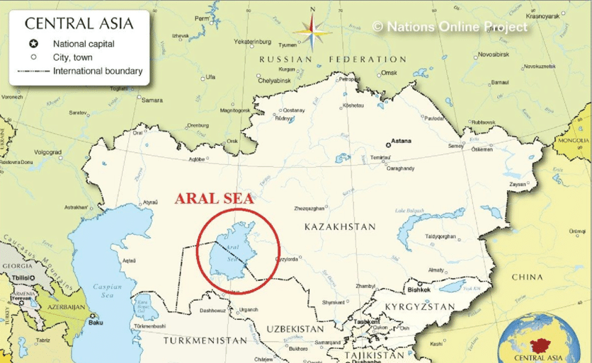
ARAL SEA:
You know where the Aral Sea is located and why it is so famous, let me tell you about the Aral Sea, its location and what you should remember for the exam
Location
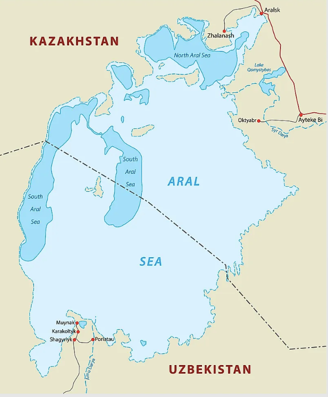
The Aral Sea is situated in Central Asia, between the southern part of Kazakhstan and North Uzbekistan.
Till the 1960s, it was the world’s fourth largest saline lake ( after Caspian, Balkash Kazakhstan), and Turkana ( Kenya, Ethiopia ).
Two important rivers that feed into the lake are the Syr Darya and Amu Darya rivers, reaching the sea through north and south respectively. ( Please remember these names for an exam).
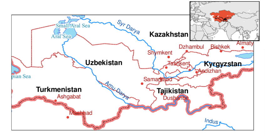
Until the 1960’s the two rivers accounted for around 75 – 80% of the water supplied to the lake (the rest was rainfall).
In the
1960s USSR decided to divert these rivers for irrigation purposes which led to a drastic reduction in the size of the sea.
Impact :
- Reduction in the size of the lake ( the size of the lake has declined to less than 10% of its original size).
- Increase in salinity (lake salinity level has risen from 10 gram/ 1 to cover 100g/1)
- Death of marine species such as barbell, carp, etc.( due to reducing water levels and salinity).
Restoration strategy:
The five central Asian countries adopted the Aral Sea Basin Program in 1995 as part of the restoration strategy. the program aimed to stabilize the basin’s environment, rehabilitate the area around the sea, and improve the lake’s water management.
Russia
MURMANSK PORT
Murmansk is a seaport located in Northwestern Russia. It lies 200km north of the Arctic Circle and is on the eastern shore of Kola Bay,48 km from the ice-free Barents Sea.
The town was founded in 1915 as a supply port in WW-1, It was a base for the British, French, and American expeditionary forces against the Bolsheviks in 1918.
In WW – 2 also the port served as the main port for the Anglo-American Convoys carrying war supplies to the USSR through the Arctic Ocean.
Current scenario:
Now, it is an important fish port having one of the largest fish processing facilities in Europe. Its ice-free harbour makes it Russia’s only port with unrestricted access to the Atlantic and world sea routes. From Dec – May it replaces the icebound St. Petersburg as the major port of the northwest. It is connected by railroad to St Petersburg and Moscow.
Why it was in the news:
India’s engagement with Russia’s Arctic region has been strengthening with India-bound goods constituting the maximum share of cargo handled in 2023 (Jan – July) by Murmansk port.
Coal was the main item imported in India from the Russian Port.
Chechnya
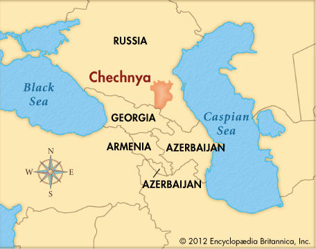
Chechnya (its official name is the Chechen Republic) is a republic of Russia. It is located in the North Caucasus region.
The republic forms a part of the North Caucasian Federal District. It is bordered by Russia proper on the north, the Dagestan Republic on the east and southeast, the country of Georgia on the southwest, and the Ingushetia Republic on the west.
Insurgency: History
Chechen-Ingush was designated as a republic in 1936. Secessionist sentiments emerged in 1991 with the disintegration of the USSR.
• A coup against the local communist government was carried out in 1991, and the coup leader Dzhokhar Dudayey unilaterally declared Chechnya’s independence from the Russian Federation (subsequently Russia).
• In 1992, Chechnya-Ingushetia divided into two separate republics with Ingushetiya favoring Russia and Chechnya leader favoring independence.
• Russian forces took over in March 1995 and Dudayey was killed in 1996. A peace treaty was signed in 1997.
• But after a bombing killed scores of civilians in Russia, the then PM Vladimir Putin blamed Chechnya and the Russian forces re-entered Chechnya in 1999.
The above points in simple language mean Chechnya, officially known as the Chechen Republic, is a region in Russia located in the North Caucasus. It became a republic in 1936 but saw secessionist movements emerge in 1991 after the collapse of the Soviet Union. This led to a coup against the local government, with Chechnya’s leader, Dzhokhar Dudayev, declaring independence from Russia. In 1992, Chechnya and Ingushetia split into separate republics, with Chechnya pushing for independence. Russian forces intervened in 1995, resulting in Dudayev’s death in 1996 and a peace treaty in 1997. However, after a bombing in Russia blamed on Chechnya in 1999, Russian forces re-entered Chechnya under the leadership of then-Prime Minister Vladimir Putin.
MOSCOW AND MARCH 2024 TERROR ATTACK
Moscow is the capital and the largest city in Russia. The city is located on the Moskva River in central Russia. It is the most populous city of entire Europe and the largest city by land area on the European continent.
Note: In 1712, under the reign of Peter the Great, the Russian capital was moved to the newly founded St. Petersburg which diminished Moscow’s role and influence. But after, the Russian Revolution the capital was moved back to Moscow in 1918, where it became the political centre of the USSR and later of Russia.
March 2024 Terror Attack:
• The terror attack took place at Crocus City Hall on the outskirts of Russia on 22nd March and killed around 150 people. This is the deadliest terror attack Russia has seen in a decade.
Who has claimed the attack?
Islamic State (IS) has claimed responsibility for the attack. American officials have attributed it to ISIS-K, a branch of the group.
• Russian authorities have accused four men from Tajikistan of being behind the attack. Russian President Vladimir Putin has said that “Russian Islamists” carried out the attack, but also claimed without proof that a “window” had been prepared for the attackers to escape to Ukraine. Kyiy has denied the allegations.
Who are ISIS-K?
ISIS-K was formed in 2015 and has been active in AF, PAK, and Iran. It is a branch of ISIS, the terror group that emerged in Iraq and Syria and at its peak, controlled a huge stretch of territory.
Why attack Russia?
Russia has been at the top or near the top of the list of ISIS for many years. Moscow’s crucial role in the Syrian Civil War, when it intervened in support of the Syrian government and against ISIS is a primary reason.
ISIS propaganda has long targeted Russia for its brutal tactics in Chechen wars.
LAKE BAIKAL

It’s a large rift lake in Russia. Lake Baikal is a rift valley, created by the earth’s crust slowly moving apart. In geological terms is rift is young and active and widens about 4 mm per year. The fault zone is also seismically active.
It is located in southern Siberia—7th largest lake in the world in terms of surface area and the largest in Asia.
It is also the world’s largest freshwater lake in terms of volume of water. It stores more than 20% of the world’s fresh surface water. This is more than all of North America’s great lakes combined.
It is also the world’s deepest lake (depth of 1620 km). (Lake Tanganyika (1436m); Caspian Sea (1,025 m); Vostok (900 m); Lake Martin (836 m));
It is also one of the UNESCO’s World Heritage Site.
For more updates follow https://www.instagram.com/mateenahaya,
till then you can read https://mateenahaya.com/index.php/2024/03/17/r0ad-infrastructure-getting-smarter/
Pingback: Decoding India and Indian geographical Best facts ,UPSC 2024
Pingback: Top 10 places on Map in News 2024 ( International Map FACTS PART 2) - Mateenah Aya