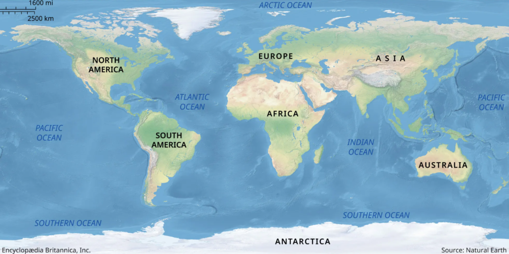
in this article you will understand the location of this place, why it was in the news, the Map, and what the government exam can ask on this paper. look at the above map which is a world map before proceeding you should know all continents and oceans majorly.
KACHIN PROVINCE (Map ):
Location:
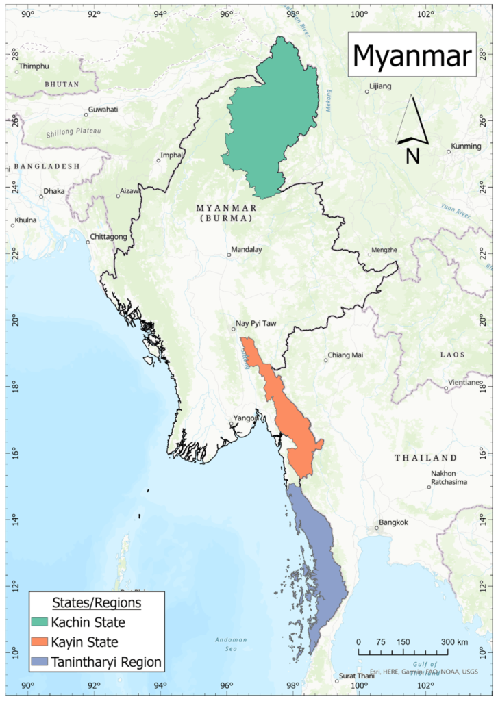
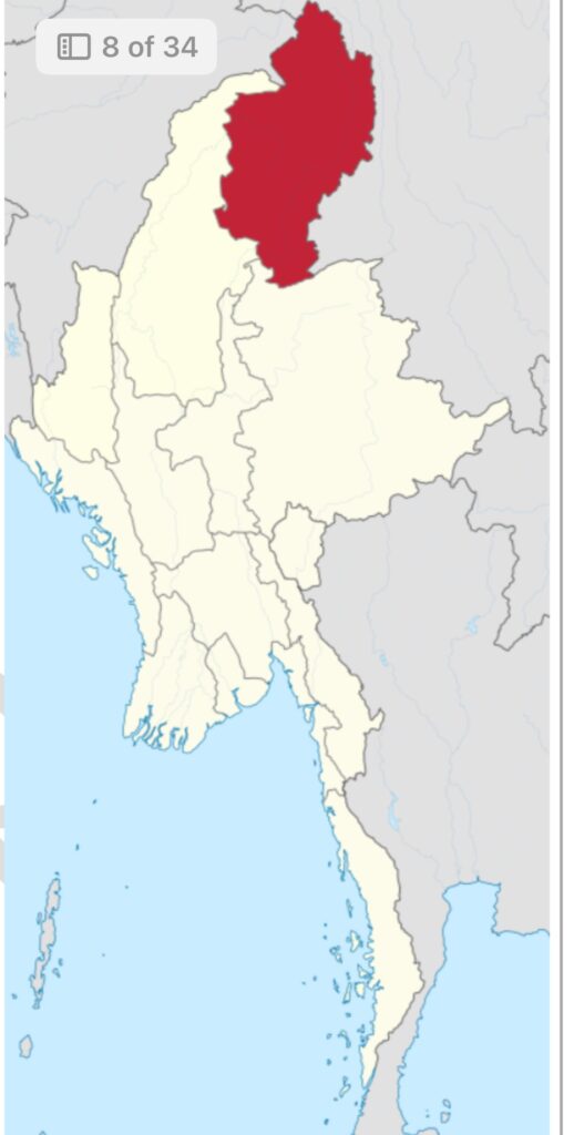
KACHIN PROVINCE LOCATION Look at the Map the red one ( Source – World Map)
It is the northernmost state of Myanmar bordering China in the north and east and India in the west. See Map and find out and mark it.
China’s claim:
Various Chinese governments over the years have claimed over northern half of the Kachin state as Chinese territory since the 18th century.
Reasons for insurgency in Kachin:
Removal of autonomy:( See map again)
When the Kachin state was formed after the independence of Myanmar, it was allocated a lot of autonomy. But it changed after the 1962 Burmese coup d’etat. The Ne Win regime which came into power in 1962 unilaterally abrogated the Constitution.
Declaration of Buddhism as a state religion:
Kachin armed group was established in 1960 after the U Nu government announced the state religion as Buddhism. The Kachin people stopped believing in the government administration system, established after the federal union was agreed upon in 1947 agreement.
Kachin Independence Organization:
With the unilateral abrogation of the Union of Burma Constitution by the Ne Win government in 1962, Kachin forces withdrew from Burmese army and formed the Kachin forces withdrew from Burmese army and formed Kachin Independence Army (KIA) under the Kachin Independence Organisation (kio)
The conflict between KIA and Myanmar forces has extended into the 2020s
GWADAR PORT
Map :
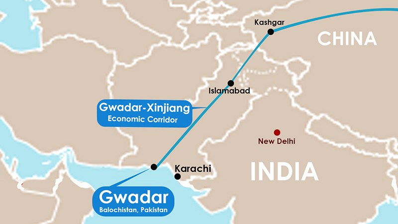
It is situated on the Arabian Sea in Pakistan’s Baluchistan Province. It is located around 170 km east of Chabahar Port. Look at the map and see.
It is under the administrative control of the Maritime Secretary of Pakistan.
The port has substantial Chinese investment and features prominently in the Pakistan Economic Corridor.
News:
On March 20, 2024, Pakistan security forces thwarted a complex coordinated attack on the Gwadar Port Authority Complex in a two-hour-long battle and claimed to have neutralized all eight militants. Two soldiers have been killed in action.
TheMajeedBrigadeoftheBaluchistanLiberationArmy(BLA), claimed the responsibility for the attack. They stressed that their fighters have targeted Pakistan’s ISI and military intelligence facilities.
| Note: Balochistan and Gwadar ports are immensely important for Pakistan, especially for the army that has taken on the responsibility of making the CPEC and its end port, Gwadar, a success story of China’s BRI. |
BALOCHISTAN PROVINCE ( See Map First )
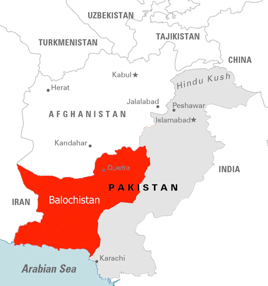
Balochistan is located in the southwest of Pakistan.
It is the country’s largest and most sparsely populated province.
It has huge natural resources like oil reserves and abundant natural resources. But the ethnic Baloch are Pakistan’s poorest and most under-represented people
Capital:
Quetta
INSURGENCY IN BALOCHISTAN:
History:
At the time of partition, Balochistan comprises multiple chiefdoms owing allegiance to the British. Ahmed Yar Khan, the chief of Kalat, was the most powerful of these tribal chiefs and hoped to secure an independent state for his people. However, he was forced to accede in 1948, after Pakistan invaded Kalat. This triggered the insurgency which continues even today.
– Other factors which has fuelled insurgency in the region are see Map
» Economic deprivation
» Lack of political freedom
» Forced disappearance of thousands of men
» Extrajudicial killings of many of those reported missing
» Other forms of repression by Pakistani state.
– In many ways, China-backed Gwadar port is a symbol of injustice for the Balochi people. Despite rampant unemployment in the province, engineers and technical specialists were hired from Punjab, Sindh and even China. In recent years, Baloch militants have repeatedly targeted both Gwadar and Chinese nationals in the country.
– Baloch armed groups including, Baloch Liberation Army (BLA), Baloch Liberation Front (BLF), Baloch Nationalist Army (BNA), and Baloch Republican Guard (BRG) have created an operational umbrella alliance under the banner of Baloch Raaji Aajoi Sangar (BRAS) in 2018 to coordinate their action on the ground.
» The BRAS have claimed more than 600 attacks and more than 600 casualties of armed forces in 2023.
– The Baloch insurgency in Pakistan has been gaining momentum for the past two years and insurgents can regularly breach the perimeter security of Pakistan military and paramilitary installations across Balochistan in bold, frontal attacks.
MAJID BRIGADE
The Majeed Brigade is the separatist group of the Baloch Liberation Army (BLA). It has claimed responsibility of the attack on a complex outside Gwadar Port.
The Majed Brigade has been active since 2011 and is the BLA’s dedicated suicide squad. The unit is named after two brothers, both of whom were called Majeed Langove (Sr and Jr).
History:
In May 1972, the National Awami Party (NAP) came to power in Balochistan. Nationally, the NAP sat in opposition to Prime Minister Zulfiqar Ali Bhutto’s Pakistan People’s Party (PPP). The NAP had long advocated for greater regional autonomy in Pakistan, and it was emboldened by the secession of BD in 1971.
However, Bhutto was not willing to give a concession and created problems in the functioning of the NAP government in Balochistan. The NAP government was finally dismissed in Feb 1973. This led to both the insurgency and the Pakistani state repression becoming worse in Balochistan. Between 1973, thousands of insurgents and military officials were killed.
In this background, Majeed Langove Senior, then a young Baloch man, decided to assassinate Bhutto. In 1974, when Bhutto arrived in Quetta to attend a public gathering, Majeed senior waited atop a tree, a grenade in hand. He had no plans to escape and was most certainly going to die. He eventually died. The grenade burst in Majid Senior’s hand as he waited for Bhutto’s motorcade.
Junior’s Sacrifice and formation of Majid Brigade:
The death of Majeed Senior was mythologized for posterity by the actions of his younger brother, Majeed Langove Junior, who was born two years after Senior was killed. In 2010, Junior was killed in a fight against Pakistani forces. His death was mourned by nationalists across Balochistan. After it became widely known that he was the brother of Majid senior who too had given life four Balochi freedom, the Majeed Langrove brothers were raised to near mythical status.
When Aslam Achu, a BLA leader, decided to establish a suicide squad, he named it after the ‘Majeed’ brothers as ‘the Majeed Brigade’. The first attack by the MaBrigadegade took place in 2011. After a long hiatus, the group became active again in 2018 and attacked a Bus carrying Chinese engineers in Dalbandin near the Pakistan-Afghanistan border. The brigade has also attacked the Chinese consulate in Karachi (2018) , the Gwadar Pearl Continental Hotel ( 2019), and the Pakistan Stock Exchange in Karachi ( 2020).
Europe:
Map:
- CATALONIA ON MAP:
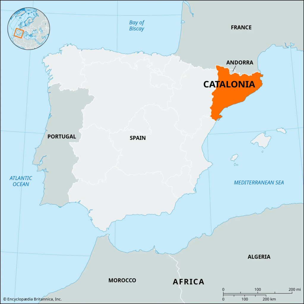
Catalonia is a historic region of Spain including the northeastern provinces of Girona, Barcelona, Tarragona, and Lleida. The autonomous community of Catalonia occupies a triangular area in the north-eastern corner of Spain.
It is bordered by France and Andorra to the north, and the Mediterranean Sea to the south and East. It also borders the autonomous community of Valencia to the south and the autonomous community of Aragon, to the west.
The Pyrenees separate Catalonia from France
Growing Call for Independence:
Since the 2010s, there has been a growing support for Catalan independence.
• In Oct 2017, the Catalan Parliament unilaterally declared independence following a referendum that was deemed unconstitutional by the Spanish state.
• The Spanish senate voted in favour of direct rule by removing the Catalan government and calling a snap regional election. The Spanish Supreme Court also imprisoned seven former ministers of the Catalan government on charges of rebellion and misuse of public funds. But in 2021, all those in Prison were pardoned by the Spanish government.
In Dec 2023, Pere Aragones, the President of the Government of Catalonia wrote in Financial Times that Catalonia is a nation with a rich historical legacy, which is diverse and modern and is bound by its language, Catalan. A nation with a persistent desire for self-governance dating back centuries. A nation that wants to be free, that wants to be able to democratically and peacefully decide how it governs itself and wants to create a new state, independent of Spain, but working together with it within the European Framework.
AFRICAN MAP
LAKE FAGUIBINE ON MAP:
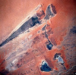
It was a lake in Mali on the southern edge of the Sahara desert. It was situated 75 km north of the Niger River to which it is connected by a system of smaller lakes and channels.
During heavy flooding, the water from the Niger River reaches the lake. But since the Sahel drought of the 1970s and 80s, the lake has mostly remained dry. Water has reached the lake in very few cases. All this has contributed to the partial collapse of the ecosystem of the region.
In the year 2021, the lake was completely dry.
The Lake Faguibine system: The lake forms a system of five interconnected lingering depressions that fill to different extents every year based on the level of rainfall and flood
LAKE VOLTA ON MAP :
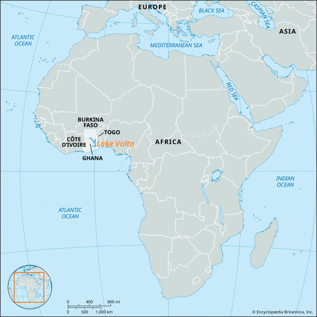
Lake Volta is an artificial lake in Ghana. It is formed by the Akosombo Dam over the Volta River.
With a storage capacity of 153 Billion cubic meters, it is one of the largest artificial lakes in the world. It covers around 8502 sq km (3.6% of Ghana’s area). The lake lies completely within Ghana.
The lake is located on Prime Meridian.

Akosombo Dam holds back both the White Volta River and the Black Volta River which formerly converged where the middle of the reservoir lies now, to form a single volta river.
The present Volta River flows from the outlet of the dam’s powerhouse and spillways to the Atlantic Ocean in southern Ghana.
It is navigable and provides a cheap route connecting Ghana’s Savanna to the coastal region.
MOZAMBIQUE :
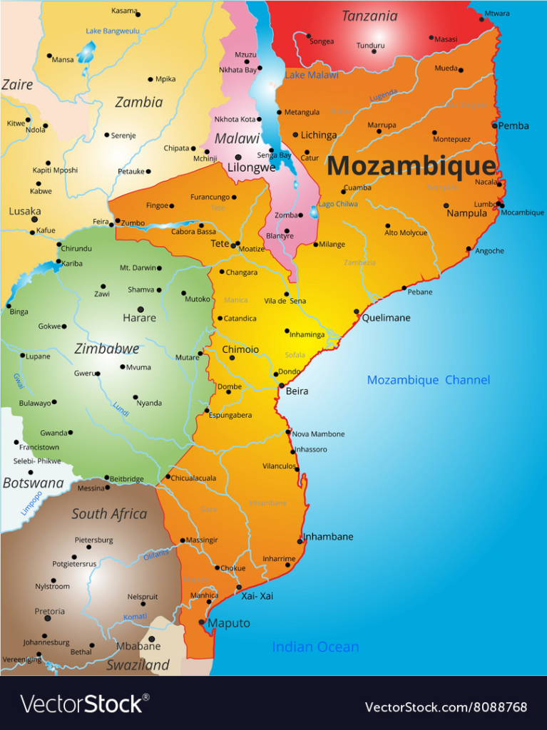
It’s a country located in southeastern Africa with its capital as Maputo. It has a tropical climate. It has an extensive coastline, fronting the Mozambique Channel,
which separates mainland Africa from the Island of Madagascar.
Bordering countries: South Africa and Swaziland in the south and southwest; It is ordered by Zimbabwe to its west; Zambia and Malawi on its northwest and Tanzania to its north.
The great Zambezi River has provided ample water for irrigation and is the basis for the regionally important hydroelectricity power industry.
It gained independence from Portugal in 1975. But it was soon engulfed in civil war.
1977-92: Civil War: Mozambican civil war between the Frelimo government, with support from Cuba and USSR, and anti-communist Mozambican National Resistance (Renamo) rebels, combined with sabotage from the neighbouring states of Rhodesia and South Africa. Over a million people die in the fighting and subsequent famines.
990: Constitution was amended to allow a multi-party system and the first multi-party elections were held in 1994.
017: A jihadist insurgency has begun on the northern side.
CABO DELGADO :

Cabo Delgado: It is the northernmost province of Mozambique and borders Tanzania to its north and the Indian Ocean to its east.
tarting 2017, armed Islamist extremists linked to the Islamic State of Iraq and Evans launched a jihadist insurgency in the Cabo Delgado region. The insurgent group sometimes referred to itself as Shabaab. (Please note that they are different
from Somali-Al Shabaab).
March 2024: More than 70 children are missing following a recent jihadist attack in Mozambique’s northern Cabo Delgado. They became separated from their family as thousands fled to a neighbouring province in recent weeks. There are ears that some of them may have been kidnapped by fighters linked to ISIS.
NORTH AMERICA MAP :
THE POPOKATEPETI VOLCANO:
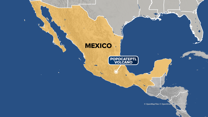
popocateptl volcano on map
The Popocatepetl Volcano:
It is Mexico’s most dangerous volcano. It is located just outside Mexico City (72 km southeast).
Note: Popocatepetl means “smoking mountain” in the Aztec Nahuatl language.
In Feb 2024, it erupted 13 times in a single day. It spewed thick plumes of volcanic ash into the sky causing flights to be grounded. It has also blanketed the capital and the surrounding area with thick plumes of ash.
PREVIOUS YEAR QUESTIONS FROM THE MAP
Q1 Which one of the following is a part of the Congo Basin?
(a) Cameroon
(b) Nigeria
(c) South Sudan
(d) Uganda
Q2 Consider the following pairs:
Area of conflict mentioned in news: Country where it is located
1. Donbas: Syria
2. Kachin: Ethiopia
3. Tigray: North Yemen
How many of the above pairs are correctly matched? (a) Only one
(b) Only two
(c) All three
(d) None
3 Consider the following countries:
1. Bulgaria
2. Czech Republic 3. Hungary
4. Latvia
5. Lithuania
6. Romania
How many of the above-mentioned countries share a land border with Ukraine? (a) Only two
(b) Only three
(c) Only four
(d) Only five
4 In recent years Chad, Guinea, Mali and Sudan caught international attention for which one of the following reasons is common to all of them?
(a) Discovery of rich deposits of rare earth elements
(b) Establishment of Chinese Military bases
(c) Southward expansion of the Sahara Desert
(d) Successful coups
5 Consider the following pairs:
Regions often Reason for being in the news
1. North Kivu and Ituri: War between Armenia and Azerbaijan
2. Nagorno-Karabakh: Insurgency in Mozambique
3. Kherson and Zaporizhzhia: Dispute between Israel and Lebanon How many of the above pairs are correctly matched?
(a) Only one
(b) Only Two
(c) All three
(d) None
6 Which one of the following lakes of West Africa has become dry and turned into a desert?
(a) Lake Victoria
(b) Lake Faguibine
(c) Lake Oguta
(d) Lake Volta
7 The term “Levant” often heard in the news roughly corresponds to which of the following regions?
(a) Region along the eastern Mediterranean shores
(b) Region along North African shores stretching from Egypt to Morocco
(c) Region along the Persian Gulf and the Horn of Africa
(d) The entire coastal areas of the Mediterranean Sea
8 Consider the following countries: 1. Azerbaijan
2. Kyrgyzstan
3. Tajikistan
4. Turkmenistan 5. Uzbekistan
Which of the above has borders with Afghanistan?
(a)1,2and5only
(b)1,2,3and4only
(c)3,4and5only
(d)1,2,3,4and5
IB Consider the following countries:
1. Armenia
2. Azerbaijan
3. Croatia
4. Romania
5. Uzbekistan
Which of the above are members of the Organization of Turkic States?
(a)1,2and4
(b)1and3
(c)2and5
(d)3,4and5
9 Which one of the following statements best reflects the issue with the Senkaku Islands, sometimes mentioned in the news?
(a) It is generally believed that they are artificial islands made by a country around the South China Sea.
(b) China and Japan engage in maritime disputes over these islands in the East China Sea.
(c) A permanent American military base has been set up there to help Taiwan increase its defence capabilities.
(d) Through the International Court of Justice declaring them as no man’s land, some South-East Asian countries claim them.
10 Consider the following pairs: Region often mentioned in the news Country 1. Anatolia – Turkey
2. Amhara – Ethiopia
3. Cabo Delgado – Spain
4. Catalonia – Italy
How many pairs given above are correctly matched? (a) Only one pair
(b) Only two pairs
(c) Only three pairs
(d) All four pairs
11 In which one of the following groups are all the four countries members of G20?
(a) Argentina, Mexico, South Africa and Turkey
(b) Australia, Canada, Malaysia and New Zealand
(c) Brazil, Iran, Saudi Arabia and Vietnam
(d) Indonesia, Japan, Singapore and South Korea
12 Consider the following pairs:
River: Flows into
1. Mekong: Andaman Sea
2. Thames: Irish Sea
3. Volga : Caspian Sea
4. Zambezi : Indian Ocean
Which of the pairs given above is/are correctly matched?
(a)1and2only
(b) 3 only
(c)3and4only
(d)1,2and4only
13 Consider the following pairs:
Sea: Bordering country
1. Adriatic Sea : Albania
2. Black Sea: Croatia
3. Caspian Sea: Kazakhstan
4. Mediterranean Sea: Morocco
5. Red Sea: Syria
Which of the pairs given above are correctly matched?
(a)1,2and4only
b)1,3and4only
(c)2and5only
(d)1,2,3,4and5
14 Which of the following has/have shrunk immensely/dried up in the recent past due to human activities?
1. Aral Sea
2. Black Sea
3. Lake Baikal
Select the correct answer using the code given below: (a) 1 only
(b)2and3
(c) 2 only
(d)1and3
15 Consider the following pairs:
Towns sometimes mentioned in news – Country
1. Aleppo – Syria
2. Kirkuk – Yemen
3. Mosul – Palestine
4. Mazar-i-sharif – Afghanistan
Which of the pairs given above are correctly matched? (a)1and2
(b)1and4
(c)2and3
(d)3and4
16 Consider the following pairs:
Regions sometimes mentioned in news – Country
1. Catalonia – Spain
2. Crimea – Hungary
3. Mindanao – Philippines
4. Oromia – Nigeria
Which of the pairs given above are correctly matched?
(a)1,2and3
(b)3and4only
(c)1and3only
(d)2and4only
2017
17 Mediterranean Sea is a border of which of the following countries?
1. Jordan 2. Iraq
3. Lebanon 4. Syria
Select the correct answer using the code given below:
(a)1,2and3
(b)2and3only
(c)3and4only
(d)1,3and4only
18 Which of the following is geographically closest to Great Nicobar?
(a) Sumatra (b) Borneo (c) Java
(d) Sri Lanka
2015
19 The area known as ‘Golan Heights’ sometimes appears in the news in the context of the events related to
a) Central Asia
(b) Middle East
(c) South-East Asia
(d) Central Africa
20 Which one of the following countries of South-West Asia does not open out to the Mediterranean Sea?
(a) Syria
(b) Jordan
(c) Lebanon
(d) Israel
2014
21 Consider the following pairs: Region often in the news: Country
1. Chechnya: Russian Federation
2. Darfur: Mali
3. Swat Valley: Iraq
Which of the above pairs is/are correctly matched?
(a) 1 only
(b)2and3only
(c)1and3only
(d)1,2and3
22 Turkey is located between
(a) Black Sea and Caspian Sea
(b) Black Sea and Mediterranean Sea
(c) Gulf of Suez and Mediterranean Sea
(d) Gulf of Aqaba and Dead Sea
23 What is the correct sequence of occurrence of the following cities in Southeast Asia as one proceeds from south to north?
1. Bangkok
2. Hanoi
3. Jakarta
4. Singapore
Select the correct answer using the code given below:
(a) 4-2-1-3
(b) 3-2-4-1
(c) 3-4-1-2
(d) 4-3-2-1
2013
24 Which one of the following pairs is correctly matched?
Geographical Feature: Region
(a) Abyssinian Plateau : Arabia
(b) Atlas Mountains: North-Western Africa
c) Guiana Highlands: South-Western Africa
(d) Okavango Basin: Patagonia
2010
25 Which one of the following can one come across if one travels through the Strait of
Malacca:
a) Bali
b) Brunei
c) Java
d) Singapore
2009
26 Consider the following countries:
1. Australia
2. Namibia
3. Brazil
4. Chile
Through which of the above does the Tropic of Capricorn pass?
a) 1 only
b)2,3and4
c)1,2and3
d)1,2,3and4
2008
27 Which one of the following cities is nearest to the equator?
a) Colombo
b) Jakarta
c) Manila
d) Singapore
28 Which one of the following straits is nearest to the International Date Line?
a) Malacca Strait
b) Bering Strait
c) Strait of Florida d) Strait of Gibraltar
29 In which one of the following is Malta located?
a) Baltic Sea
b) Mediterranean
c) Black Sea
d) North Sea
30 Which of the following countries share borders with Moldova?
1. Ukraine 2. Romania 3. Belarus
Select the correct answer using the code given below:
a)1and2only
b)2and3only
c)1and3only
d)1,2and3
31 Through which one of the following Straits, does a tunnel connect the United Kingdom and France?
a) Davis Strait
b) Denmark Strait
c) Strait of Dover
d) Strait of Gibraltar
32 Which one of the following cities does not have the same clock time as that of the other three cities at any given instant?
a) London (U.K)
b) Lisbon (Portugal)
c) Accra (Ghana)
d) Addis Ababa (Ethiopia)
To read the first part of international map 1 click https://mateenahaya.com/index.php/2024/04/03/international-mapping-upsc/
OR https://mateenahaya.com/index.php/2024/03/18/indian-location/
visit for more updates: instagram
Pingback: 18 important Man Biosphere Reserve UPSC 2024 facts
Awesome !
Thanks for this article .
Love your content
Great work, Your content is upto date .love it
Pingback: British Rule in india ( Top 100 Facts about European power)