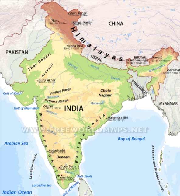
This is the map of India. Look closely at the map and examine the northernmost latitudes, southernmost latitudes, and easternmost and westernmost longitudes. To simplify, the mainland of India extends from Kashmir in the north to Kanyakumari in the south, Gujarat in the west, and Arunachal Pradesh in the east. It’s important to note that questions regarding the locations of the eastern, western, northern, and southern extremities are commonly asked in exams, so please be attentive.
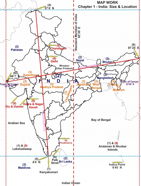
Our southern boundary extends up to 6’45 N latitude in the Bay of Bengal let me explain to you what this means. This means the bottom part of India, where it meets the sea in the Bay of Bengal, goes as far south as this latitude line before reaching other countries or territories. It’s like drawing a line on a map to show how far south India goes in the Bay of Bengal. Let me make this more simple for you.
For example, you have a globe or a map of the world. Latitude lines are imaginary horizontal lines that measure how far north or south a place is from the equator. The equator is at 0 degrees latitude and marks the halfway point between the North Pole and the South Pole.
Now, when we say “6 degrees 45 minutes North latitude,” it means we’re looking at a latitude line that’s 6 degrees north of the equator, plus an additional 45 minutes.
To make it simpler, think of a circle divided into 360 degrees. Each degree can be further divided into 60 minutes, for example, an hour can be divided into 60 minutes. So, when we say 6 degrees 45 minutes, it means we’re moving north from the equator by 6 full degrees and then an additional 45 minutes. That is 6 hours and 45 minutes from the equator.
So, the southern boundary of India extends up to a latitude line that’s 6 degrees and 45 minutes north of the equator in the Bay of Bengal. Can you check any southern hemisphere country having the same latitude? This is your home task.
If you work out the latitudinal and longitudinal extent of India, they are roughly about 30 degrees, whereas the actual distance measured from north to south extremity is 3,214 km, and that from east to west is only 2,933 km. What is the reason for this difference?
For example, you’re measuring the length and width of India like you would measure a piece of paper. When we talk about the length (north to south), it’s roughly about 3,214 kilometres. This means if you could stretch Bharat from its northernmost point to its southernmost point, it would cover a distance of 3,214 kilometres.
Now, when we talk about the width (east to west), it’s only about 2,933 kilometres. This means if you could stretch your country from its easternmost point to its westernmost point, it would cover a distance of 2,933 kilometres.
Now, you might be thinking why the difference in the numbers when we talk about the actual latitudinal and longitudinal extent, which are roughly about 30 degrees. That’s because the Earth is round, not flat like a piece of paper. When you measure distances on a globe, they can appear shorter than when you measure them in straight lines on a map.
So, even though It’s latitudinal (north-south) and longitudinal (east-west) extent is about 30 degrees, the actual distances from one extreme point to another are different due to the curved shape of the Earth.
The distance between two latitudes remains the same everywhere. You can imagine lines running horizontally on a globe. These are the latitudes. That does not matter where you are on Earth, the distance between two of these lines (latitudes) is always the same.
Now, let’s talk about why this matters . India’s location on the globe means that its southern part is closer to the equator, which is in the tropics, while its northern part is closer to the subtropical zone or the warm temperate zone. This positioning leads to big differences in things like the shape of the land, the weather, the type of soil, and the plants that grow there. You know that in your country in some parts there is snowfall and in some parts summer remains 12 months, small places are Desertic and some parts are always experiencing rainfall, it is because of this. There are seven plus kinds of soil, some places hilly and some plain, etc.
Therefore, because your country stretches across different latitudes, it experiences a wide range of climates and landscapes, from the hot and tropical south to the milder and subtropical north.
The longitudinal extent and its implications on the Indian people.
For example, you’re standing in different parts of India, let it be Arunachal Pradesh from the very east to the very west. Now, imagine you’re looking at the time on your watch. What you will notice is that even though the sun rises earlier in the eastern parts of India that is Arunachal Pradesh, the time shown on the watches in those places is the same as the time shown on watches in the western parts example in Gujrat.
This might seem strange at first, but it’s because of something called Indian Standard Time (IST). It has established a standard time that applies across the entire country. This standard time is based on a line of longitude called the standard meridian, which passes through a specific point in India. That is Mirzapur Uttar Pradesh state The Indian standard Meridian is located at 82’30E longitude. Friends, please do your research on which states this line passes in upsc and state exams this question has been asked.
Now, India is a large country, and it spans a wide range of longitudes, almost 30 degrees. Because of this vastness, there’s a time difference of about two hours between the easternmost and westernmost parts of the country. But by using Indian Standard Time, everyone in country follows the same time, regardless of whether it’s morning in the east or evening in the west.
So, even though the sun rises earlier in the east and later in the west, people all over India synchronize their activities using Indian Standard Time, making it easier for everyone to coordinate and communicate effectively.
Why does this happen?
Size of India :
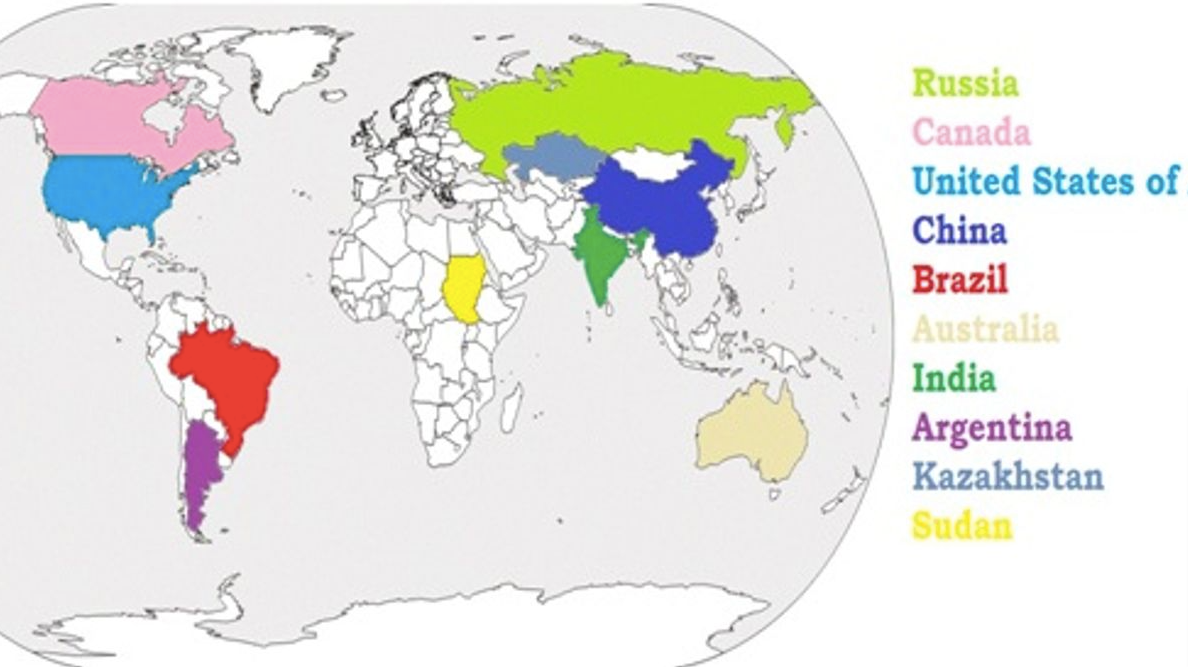
India ranks as the seventh largest country in the world by land area. Below are the names of the countries that are larger than Bharat:
-
- Russia
-
- Canada
-
- China
-
- United States of America
-
- Brazil
-
- Australia
These countries have a land area greater than India’s 3.28 million square kilometres.
For example:
-
- Russia: Russia is the largest country in the world by land area, covering over 17 million square kilometres.
-
- Canada: Canada is the second largest country in the world, with a land area of over 9 million square kilometres.
-
- China: China is the third largest country in the world, with a land area of over 9.5 million square kilometres.
-
- United States of America: The United States is the fourth largest country in the world, covering over 9.8 million square kilometres.
-
- Brazil: Brazil is the fifth largest country, with a land area of over 8.5 million square kilometres.
-
- Australia: Australia is the sixth largest country, covering over 7.6 million square kilometres.
These countries have diverse landscapes, populations, and cultures, and they play significant roles on the global stage due to their size and influence.
Because the seventh-largest country has the largest surface area India experiences great physical diversity for example,
India is a country with a lot of different landscapes and features. If you look at a map of your country, you will notice a variety of physical features:
1. Lofty Mountains in the North: In the northern part of India, you’ll find tall mountains like the Himalayas. These mountains are very high and have snowy peaks.
2. Large Rivers: India has many big rivers like the Ganga, Brahmaputra, Mahanadi, Krishna, Godavari, and Kaveri. These rivers flow through different parts of the country and are important for things like water supply, transportation, and agriculture.
3. Green Forested Hills: In the northeast and south of India, there are hills covered with lush green forests. These areas are known for their rich biodiversity and beautiful landscapes.
4. Vast Sandy Expanse: In places like Marusthali, which is also known as the Thar Desert, you’ll find large stretches of sandy desert. It’s an arid region with very little vegetation.
India is surrounded by natural boundaries:
-
- Himalayas in the North: These tall mountains act as a natural barrier between India and other countries like China and Nepal.
-
- Hindukush and Sulaiman Ranges in the Northwest: These are mountain ranges that help define India’s borders with countries like Pakistan.
-
- Purvachal Hills in the Northeast: These hills mark the eastern boundary of India.
-
- Indian Ocean in the South: India is surrounded by the Ocean to the south, which gives it a long coastline.
If you were to travel from Kashmir in the north to Kanyakumari in the south, or from Jaisalmer in Rajasthan to Imphal in Manipur, you would see a lot of different landscapes and features along the way, from mountains to rivers to forests to deserts.
It also has a long coastline, stretching about 6,100 kilometres on the mainland and even more when you include islands like Andaman and Nicobar in the Bay of Bengal and Lakshadweep in the Arabian Sea.
All these diverse features make India a physically varied and richly resourced country.
The political significance of Indian location :
 Location of India in Eastern World. ( Source – Ncert Wikipedia page)
-
- Strategic Positioning:
It is positioned in a spot where it can easily connect with different regions like South Asia, Central Asia, and Southeast Asia. This makes it important because it can influence what happens in these areas.
-
- Regional Influence:
-
- It is big and shares borders with many countries like Pakistan, China, Nepal, Bhutan, Bangladesh, and Myanmar. Because of this, it has a big say in what goes on in South Asia.
-
- Maritime Importance:
-
- It has a long coastline along the Indian Ocean. This makes it important for trade by sea. The Indian Ocean is a major route for ships carrying goods between the Middle East, Africa, and Southeast Asia. It’s location gives it control over these important sea routes.
-
- Security Concerns:
-
- Because of where it’s located, it has to deal with security issues from its neighbours. For example, there have been tensions with countries like Pakistan and China over border disputes.
-
- Economic Potential:
-
- Its location helps its trade with other countries easily. It’s close to big markets around the world, so it can sell its goods and services globally. This helps its economy grow.
-
- Diplomatic Relations:
-
- Where it is situated affects its relationships with other countries. It has to work with its neighbours and other big countries to make sure its interests are protected and to keep peace in the region.
Economic importance of Indian Location:
Trade Hub:
-
- Positioned near major sea routes and global markets, facilitating trade with Africa, the Middle East, and Southeast Asia.
Regional Gateway:
-
- Provides access to South Asian markets, fostering regional trade and economic integration.
Transportation Infrastructure:
-
- Extensive railways, roads, and ports support domestic and international trade, enhancing India’s competitiveness.
Energy Access:
-
- Proximity to oil-producing regions and natural gas reserves influences energy security strategies.
Manufacturing Centers:
-
- Coastal regions attract investments and foster industrial growth, contributing significantly to GDP and employment.
Tourism:
- Diverse geographical features attract tourists, boosting revenue and employment in the tourism industry.
- you should keep in mind that India stands as a vibrant and diverse nation, encompassing a rich cultural heritage, vast geographical landscapes, and significant historical milestones. From its struggle for independence to its emergence as a global economic player, India’s journey has been marked by resilience, diversity, and progress. With its dynamic population, thriving economy, and strategic geopolitical position, India continues to play a crucial role in shaping regional and global affairs. As India moves forward, embracing modernity while preserving its traditions, it remains a beacon of democracy, diversity, and opportunity on the world stage.
To read more articles visit: https://mateenahaya.com/index.php/2024/04/03/international-mapping-upsc/